BBlogFlow

Categories

Weather

9468 articles

Weather

Forecasts: MET Norway · Alerts: Environment Canada and NWS

Canada
United States
France

Montreal

5°C

Clear · Wind 5 km/h · Humidity 80 %

Today

15° 5°

Tomorrow

11° 6°

Tue

7° 3°

Wed

7° 1°

Weather

November hurricanes are still possible as the season winds down

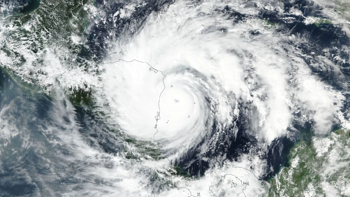
A hurricane is the farthest thing from our minds as the leaves change and temperatures drop. But the season isn’t done just yet, and even a quiet season can have a few tricks up its sleeve heading into late autumn. Here’s a look at what we might expect over the next couple of weeks as we enter the final stretch of this near-record quiet hurricane season. DON’T MISS: Autumn can still produce intense hurricanes across the AtlanticA raging El Niño in the neighbouring Pacific Ocean has kept this Atlantic hurricane season exceptionally quiet. Nine of this year’s ten named storms only achieved tropical storm intensity. Isaias, which set a record for its lateness, grew into the season’s sole hurricane before it slammed into Florida’s coastline on Oct. 9. Atlantic hurricane season officially runs through Nov. 30. Based on climatology, a little more than 90 per cent of an average hurricane season’s total activity is behind us by the weekend before Halloween. Content continues belowBut that remaining 10 per cent can pack a punch if all the right conditions align. The most likely spot for tropical formation this late in the season is the western Caribbean Sea and the southwestern Atlantic.

The Weather Network·
Weather

Halloween forecast: Will your costume need a winter coat?

Halloween is almost here across Canada! Before you put the finishing touches on your costume, you might be wondering: Will the weather co-operate? A tale of two seasons is beginning to take shape, with some Canadians facing an early taste of winter, while others could be enjoying a surprisingly mild trick-or-treat. The catch: Although we can give you some guidelines for temperature projections, nailing down a three-hour, trick-or-treat window will be futile a week out for those of us on the edge of precipitation chances. The divideAll three major weather models are showing a similar temperature divide brewing across Canada into the spooky Halloween weekend. Colder-than-seasonal temperatures are expected across parts of Western Canada, and unusually mild conditions farther east. Content continues belowParts of B. C. and Alberta could shiver through temperatures several degrees below seasonal, while the eastern Prairies and Ontario could enjoy temperatures well above what late October normally delivers. Disclaimer: Above-seasonal doesn’t necessarily mean warm. Remember it’s all relative this time of year, especially when the sun goes down.

The Weather Network·
Weather

Champi kills 1 and injures 350 in Taiwan overnight

Typhoon Champi sends towering waves over Taiwan harborChampi has killed one person and injured hundreds in Taiwan and has downed trees and knocked out power for hundreds of thousands of people. The storm's strong winds and rains continued overnight Friday into Saturday morning. ImpactsAlthough the storm is no longer a typhoon, it was the equivalent of a Category 3 Atlantic hurricane when it grazed Taiwan. Champi did not hit Taiwan directly, but the storm's span was large enough to impact most of Taiwan. The island's weather authorities said the storm was weakening Saturday morning and that by evening, the land warnings for the typhoon would be removed.(MORE: Hurricane Vance intensifies rapidly off Mexico's Pacific Coast)Taiwan’s Central Emergency Operations Center reported that 350 people were injured as of Friday night. The one death was a man who was washed away by waves in Taiwan’s Pingtung County, the island’s southernmost part. Power outages, canceled flightsThe storm knocked out power for 280,000 households, according to United Daily News, a local Taiwanese newspaper, citing the island's power authorities. But power had returned to 80% of households by Saturday morning.

The Weather Channel·
Weather

Hurricane Vance intensifies rapidly off Mexico's Pacific Coast

This GOES-19 GeoColor satellite image provided by the National Oceanic and Atmospheric Administration (NOAA) and taken on Friday, Oct. 23, 2026, shows Hurricane Vance in the Pacific.(NOAA via AP)Hurricane Vance rapidly strengthened into a Category 2 storm Friday as it neared Mexico’s Pacific Coast, the National Hurricane Center said. Vance had maximum sustained winds of 110 mph as it churned about 385 miles south-southwest of Acapulco, according to an advisory from the Miami-based hurricane center. The storm was nearing major hurricane strength, the center said, though gradual weakening was expected to start by Saturday.(MORE: Typhoon Champi sends towering waves over Taiwan harbor)The hurricane's outer bands were already funneling gale-force winds and rough seas into Mexico's Gulf of Tehuantepec, the center said. An unusually busy Pacific hurricane seasonIt’s been an intense hurricane season in the Pacific Ocean, with storms spawning in assembly-line fashion near Hawaii and Mexico as El Niño conditions create unusual weather, like this week's severe flooding and tornadoes hitting the southwestern United States and the prolonged drought in Central America's Dry Corridor.

The Weather Channel·
Weather

Hunter's Moon: When and where to see October's full moon

October’s full moon, known as the “Hunter’s moon” is coming this weekend, but weather might make the view a hit or miss for some areas. The full moon peaks late Sunday night, or early Monday morning, for anyone in the Eastern Daylight Time Zone: EDT: 12:12 am (Monday)CDT: 11:12 pm (Sunday)MDT: 10:12 pm (Sunday)PDT, MST: 9:12 pm (Sunday)Whether or not the weather will let you see the full moon is another question. A large cold front and developing low pressure system stretching across the middle third of the country will create less than ideal viewing conditions for the Plains and Upper Midwest. The Pacific Northwest is facing a similar problem with a storm system moving in from the Pacific Ocean. A super moon but not a supermoonIf you manage to get outside to view the full moon, you might describe the experience as “super”, but it is not in fact a supermoon. A supermoon happens when the moon is full at the same time as it is at its perigee, or the point in its orbit closest to the Earth. Get More of Our News on GoogleSet The Weather Company as a 'Preferred Source' to get quicker access to the news you value. The next two supermoons happen on Nov. 24  and Dec. 24.

The Weather Channel·
Weather

How to get your fussy child to wear winter clothes

Any parent of young children would agree that convincing your five-year-old to wear the right jacket or your two-year-old to keep their gloves on is not a battle you always win. "It's interesting that our kids' body temperature is often different than ours. We will often say to our kids, 'it's cold, [so] put your coat on.' They will say, 'oh, I am not cold,'" said Bethelene Hart, early childhood education, and behaviour and emotional literacy specialist. Every parent has heard that one before. Instead of convincing them otherwise, try this perspective. "We also want kids to be connected to their instincts. You know that gut feeling. And the basics are I'm hungry, I'm not hungry. I am hot. I am not hot. I am cold. You know body temperature. When we start to override that, it makes the kids not trust themselves," said Hart. (Pexels/Gustavo Fring)So, what do I say when the weather looks like this, as my child protests their jacket? Content continues below"Maybe it's not for you, and I have your coat ready when you need it. So, as parents, if your daughter goes to school in a skirt and you think, 'oh, man, her legs are going to be cold.'

The Weather Network·
Weather

Ask a met: How can you know if a cloud is forming or dissipating?

"I've always been curious how you can determine if a cloud is forming or if a cloud is dissipating. Do clouds form over the course of several hours? How long do they last? " —RubenFirst of all, thank you for your cloud question! If you’ve been around weather.com, you likely know that I love talking about all things clouds. In order to tell if a cloud is forming versus dissipating, there are a few visual cues you can look for — keeping in mind that not all cloud types behave exactly the same. Clouds that are forming typically have more defined, crisp edges and are growing in size. On the other hand, more fuzzy looking edges as well as flattening or spreading out are all indicators that the cloud is dissipating. You’ll want to make sure to observe the clouds for several minutes before coming to a conclusion because clouds are constantly changing shapes and you don’t want to be fooled. Get More of Our News on GoogleSet The Weather Company as a 'Preferred Source' to get quicker access to the news you value. To your next question, clouds can actually form much more quickly than you might think.

The Weather Channel·
Weather

Warnings persist as high winds, heavy snow hit the Prairies

Steady snowfall will continue for a wide swath of the Prairies as a blustery low-pressure system continues trekking across the region. Calgary picked up measurable snowfall early Friday. Additional accumulations are likely toward the east, with some areas on the northern Prairies picking up as much as 50 cm of snow. Warnings remain in effect for both high winds and winter storm conditions. PHOTOS: Burst of October snow falls over major Canadian citiesThe large low-pressure system responsible for the early dose of wintry weather will continue lifting north as we head into Saturday, bringing heavy snowfall to the north and blowing snow to southern regions. Wind gusts of 50-80+ km/h will persist through Saturday across Saskatchewan and Manitoba, easing into the overnight hours. Sudden reductions in visibility are expected late Friday into early Saturday across southern Saskatchewan as brief but intense snowfall accompanies the gusty winds in the region. Content continues belowRELATED: What’s the snowiest month in your corner of Canada? High snowfall rates will continue into the weekend across northern portions of Saskatchewan and Manitoba, including Cree Lake and Black Lake.

The Weather Network·
Weather

Ex-Josephine brings high winds and maybe snow to East Coast

Parts of Atlantic Canada may be in for a rough start to the weekend, with forecasters keeping a close eye on the system formerly known as Subtropical Storm Josephine. The storm has been meandering up the Eastern Seaboard this week as a powerful low-pressure system but has now reached cold North Atlantic waters. DON'T MISS: Canada's Winter Sneak Peek: El Niño puts record warmth in playThe system will swipe southern Atlantic Canada with potent wind gusts, heavy rainfall, snowfall and three- to five-metre waves along the coastal areas, elevating the risk of flooding. Low-pressure systems exist on a spectrum between tropical and extratropical (non-tropical). Josephine has slipped across the spectrum in both directions several times over the past week. Originally a strong nor’easter, the system evolved into a subtropical storm on Wednesday before returning to its roots on Thursday. A subtropical storm is one that has characteristics of both a tropical and extratropical system, a sort of hybrid storm that can bring hazardous weather to the affected regions.

The Weather Network·
Weather

Storm Austen strikes Europe as an even stronger storm looms

Winds gusted to nearly 130 km/h as powerful Storm Austen swept into western Europe to end the week. Forecasters warn that an even stronger storm will batter parts of the region heading into this weekend, threatening an additional round of powerful winds and heavy rain. DON’T MISS: How a powerful El Niño will affect people around the worldStorm Austen looked remarkable on satellite imagery as it strengthened over the northeastern Atlantic on approach to western Europe on Thursday and Friday. The centre of the powerful low-pressure system tracked east across the English Channel before weakening as it turned north over The Netherlands and Denmark late Friday. Heavy rainfall and intense winds hit Ireland, the U. K., as well as northwestern sections of mainland Europe. Gusts as high as 122 km/h at St. Mary’s Airport, off the southwestern tip of England. Another wind gust of 114 km/h occurred at a military base in Cornwall. Thousands of power outages were reported. Content continues belowStorm Boelo (pronounced ‘boo-loh’) will follow close behind, affecting northern portions of Ireland and the U. K. through Saturday and Sunday.

The Weather Network·
Weather

Super El Niño then and now: How this year's strengthening event compares to historic extremes

Super El Niño is brewing to bring an impactful winter Winter is near, and super El Niño is forecast to make it quite a winter to remember. FOX Weather Meteorologists Stephen Morgan, Bayne Froney, Britta Merwin and Craig Herrera break down the forecast and talk about past El Niño events similar to this one. THE TAKEAWAYThis year’s developing "Super El Niño" could rival some of the strongest events on record. NASA satellite data shows it currently resembles the powerful 1997–98 El Niño. Satellite imagery shows how this year’s pattern compares with two historic benchmark events. This year’s developing "Super El Niño" could become one of the strongest on record. Here’s how it compares with the powerful 1997–98 and 2015–16 events, using NASA satellite imagery captured during the same stage of each event. El Niño is the Pacific Ocean’s "warm phase. "'HISTORIC' EL NIÑO INCREASINGLY LIKELY, WITH 83% CHANCE OF BECOMING THE STRONGEST ON RECORDEvery few years, unusually warm water builds across the equatorial Pacific, weakening the trade winds and shifting tropical rainfall eastward.  The 2015-16 El Niño was also very strong, as elevated sea levels in October 2015 (middle) show.

Fox Weather·
Weather

Early Halloween weather outlook reveals how brewing Super El Niño will haunt the forecast for millions

Halloween is about a week away, and the forecast is shaping up for millions of trick-or-treaters across the U. S. It's the first time since 2020 that Halloween is on a Saturday, and Americans from coast to coast will be making the most of the weekend to celebrate. WILL THANKSGIVING BRING SNOW, RAIN OR SUNSHINE? FARMERS’ ALMANAC REVEALS ITS 2026 OUTLOOKBut will any regions in the Lower 48 see some spooky weather in their forecast as the brewing Super El Niño has full control of the nation's weather? Halloween weather outlook(FOX Weather) NortheastThe forecast in the Northeast is looking dry, as high pressure builds across the northern tier of the U. S. next weekend. A lucky thing for trick-or-treaters and those participating in any Halloween parades or outdoor festivities. Temperatures are also likely to be slightly above average, in the 60s throughout the day but maybe a little cooler in the evening. So you might be able to forgo an extra layer or jacket over your Halloween costume. BRACE FOR DARKER EVENINGS AS THE ANNUAL SEASONAL CLOCK CHANGE APPROACHES Halloween decorations outside a house in Queens area, New York, United States, on October 24, 2022.

Fox Weather·
Weather

Helicopter rescues 4 people stranded atop vehicle in raging Arizona creek as severe storms slam Southwest

The National Weather Service said repeated heavy rainfall from thunderstorms caused Wet Beaver Creek to rise nearly 4 feet. Four rescued after vehicle swept away in Arizona flood Four people were rescued from the roof of a vehicle after powerful floodwaters swept it downstream near Wet Beaver Creek in Yavapai County, Arizona. Repeated heavy rainfall from thunderstorms caused the creek to rise nearly 4 feet, triggering life-threatening flash flooding. THE TAKEAWAY4 people were rescued from a vehicle swept away by Arizona floodwaters. DPS Ranger helicopter crews airlifted the stranded occupants to safety. Heavy thunderstorms caused Wet Beaver Creek to rise nearly 4 feet. RIMROCK, AZ. – 4 people were rescued by helicopter in Rimrock, Arizona, after repeated rounds of heavy rain from severe thunderstorms caused Wet Beaver Creek in Yavapai County to rise nearly 4 feet Thursday. Strong, fast-moving currents swept a white SUV downstream, forcing four passengers onto its roof before they were rescued by an Arizona Department of Public Safety Air Rescue Unit helicopter. Four people were stranded on the vehicle’s roof after it was swept downstream by powerful floodwaters.

Fox Weather·
Weather

Permanent DST could make your morning commute more dangerous

Many provinces and regions across Canada moved away from “falling back” in 2026, permanently fixing their clocks in summer mode. This large-scale shift to year-round Daylight Saving Time (DST) will have plenty of impacts, both good and bad, on folks from British Columbia to northwestern Ontario. One of the major (and perhaps overlooked) drawbacks is the impact of darkness and winter weather on the morning commute. DON'T MISS: Sleep experts say Manitoba should reconsider daylight time over standard timeThe time shift means later sunrisesWe can’t alter the length of those short winter days, of course. But we can change how we interact with both daylight and darkness. This global debate continues to rage across Canada, the U. S., and throughout the European Union. British Columbia, Alberta, Manitoba, the Northwest Territories, and parts of northwestern Ontario decided to put a stop to the twice-annual time shift in 2026, opting to keep their respective regions on permanent summer time. This long-sought change aims to end the disruption of changing the clocks -- and schedules, and sleep patterns -- in both March and November.

The Weather Network·
Weather

Southwest faces more severe weather, flash flooding as Colorado Gov. declares state of emergency

Southwest faces another round of severe weather, flash flooding after rare Tornado Watches Another round of dangerous severe weather will shift eastward and develop over New Mexico Friday afternoon after storms triggered flash flooding and evacuations across parts of the Four Corners region Thursday. Damaging wind gusts are expected to be the main threat, but a few tornadoes are also possible. Arizona was placed under Tornado Watches on both Wednesday and Thursday, the first Tornado Watches issued in the state since 2010. Flash flooding triggered mandatory evacuations in southern Utah on Thursday.  A Level 2 out of 4 flash flood risk covers parts of southern New Mexico and West Texas Friday, while a broader Level 1 risk covers much of the rest of New Mexico, including Albuquerque and Santa Fe. THE TAKEAWAY A Level 2 out of 5 severe weather threat has been issued for southern New Mexico. Damaging wind gusts are expected to be the main threat, but a few tornadoes are also possible. A Level 2 out of 4 flash flood risk covers parts of southern New Mexico and West Texas, while a broader Level 1 risk covers much of the rest of New Mexico, including Albuquerque and Santa Fe. Colorado Gov.

Fox Weather·
Weather

Passing Pacific storm may impact weekend travel in B.C.

After a bout of notable warmth and dryness across British Columbia earlier in October, it's now the start of fall storm season for the coastal province. The season will kick off this weekend with a Pacific low brewing off the coast, although it isn't forecast to move much over the weekend. SEE ALSO: Exploring Hornby Island: Inside the "Seaweed School" adventureLuckily, the storm will stay far enough offshore to only give the province a glancing blow in terms of impactful weather. Atmospheric moisture will move in over the South Coast through Saturday and collide with a cold airmass currently sitting over the province. This will result in a quick decrease in freezing levels and a round of alpine snow along some mountain highway passes. As freezing levels fall below 1,000 metres by Saturday evening, parts of the Coquihalla and Allison Passes, as well as the Connector to Kelowna, could see 5-10 cm of snow. DON'T MISS: So long, summer: A final checklist for properly closing your cottageB. C.'s winter tire requirement for mountain passes came into effect on Oct. 1; travel may still be impacted from the Lower Mainland through the Interior late Saturday.

The Weather Network·
Weather

Burst of October snow falls over major Canadian cities

It may not even be Halloween yet, but it's beginning to look a lot like December for parts of Alberta as autumn snow descended over much of the province on Friday. SEE ALSO: Your fall vehicle checklist before winter hitsA strong low-pressure system developed across the American Rockies and pushed across the Prairies, colliding with a cold, moist airmass coming from Northern Canada. This resulted in a rapid temperature plunge, as well as gusty wind and widespread snow to all three provinces in the region. While a widespread 3-5 cm was forecast along the QE2 from Edmonton to the United States border, northern regions of the Prairies saw their first major snow event of the season. In fact, Environment and Climate Change Canada issued snowfall warnings acorss northeastern Alberta and northern Saskatchewan, as well as winter storm warnings across northern Manitoba. Locales at higher elevation, near the Rockies, were also in for slightly higher snow totals. See below for photos and videos posted onto social media of the snowy landscape many Albertans woke up to on Friday. Aerial view of a snowy Calgary neighbourhood on Oct. 23, 2026 (Connor O'Donovan/TWN)

The Weather Network·
Weather

One giant clam contains a month‑by‑month diary of the Great Barrier Reef’s climate 200 years ago

Giant Clam (Tridacna gigas) from Jiigurru (Lizard Island Group). (Andy Lewis/Coral Sea Foundation)When you swim through the azure waters of the Great Barrier Reef, there is one entity on the seafloor that’s almost impossible to miss: the giant clam. Its huge, fluted shell frames a soft mantle shimmering with electric blue, green and gold. As the world’s largest living bivalve, Tridacna gigas can reach 1.2 metres, weigh more than 200 kilograms and live for over a century. Across their long lives, these clams record their daily life in their shells, creating an autobiographical shell diary. In our new research, we read one of these shell diaries to reconstruct month-by-month climate conditions at Jiigurru (also known as the Lizard Island Group), in the northern Great Barrier Reef. The shell’s story reveals that, before widespread industrial-era warming, Jiigurru’s summers were cooler than today, while winters were surprisingly similar. Jiigurru (Lizard Island Group) showing Blue Lagoon where our giant clam recorded its shell diary. (Sean Ulm)How can a shell keep a diary?

The Weather Channel·